* This phone number available for 3 min is not the recipient’s number but a number from a service which will put you through to that person.
This service is produced by Kompass.
Service & free calls*
* This number, only available 3 minutes, is not your correspondant’s number but the number of a service putting you through to that person.This service is produced by Kompass.
All the lines are busy at the moment, please try again in a moment.
Presentation - Marks
Expertise in Geospatial Solutions: Photogrammetry, Lidar, Surveying, and MoreAt our company, we specialize in providing comprehensive geospatial solutions for various industries. Our team of experts is well-versed in the latest technologies and techniques, including:
Using these technologies, we offer accurate and detailed geospatial data to help our clients make informed decisions. Whether you need to map your land, inspect infrastructure, or create a BIM model, we have the expertise and equipment to get the job done.Photogrammetry: Precision Mapping from PhotosPhotogrammetry is the science of making measurements from photographs, especially for recovering the exact positions of surface points. Our team uses the latest photogrammetry software and equipment to create highly accurate 3D models of the world around us.Lidar: Measuring the World with LightLiDAR (Light Detection and Ranging) is a remote sensing technology that uses laser light to measure distances. Our LiDAR systems can create highly detailed 3D models of the terrain, buildings, and infrastructure. This data is essential for applications such as topographic mapping, infrastructure inspection, and urban planning.Surveying: Measuring the World with PrecisionSurveying is the science of making precise measurements to determine the position of points and the distances and angles between them. Our team uses the latest surveying equipment and techniques to provide accurate and reliable data for a variety of applications, including construction, engineering, and land development.Cadastral Mapping: Defining Property BoundariesCadastral mapping is the process of creating and maintaining maps that define the boundaries of land parcels. Our team uses the latest mapping technologies and techniques to create accurate and detailed cadastral maps that help our clients manage their property and land records.UAV Inspection: Inspecting Hard-to-Reach AreasUAV (Unmanned Aerial Vehicle) inspection is a cost-effective and efficient way to inspect hard-to-reach areas. Our team uses the latest UAV technology to capture high-resolution images and video of infrastructure, buildings, and terrain. This data is essential for applications such as infrastructure inspection, construction monitoring, and environmental monitoring.BIM: Building Information ModelingBIM (Building Information Modeling) is a digital representation of the physical and functional characteristics of a building. Our team uses the latest BIM software and techniques to create accurate and detailed models that help our clients design, construct, and manage their buildings. BIM models can be used for a variety of applications, including facility management, construction planning, and design coordination.Underground Utility Mapping: Locating Hidden AssetsUnderground utility mapping is the process of creating detailed maps of underground utilities and infrastructure. Our team uses the latest utility mapping technology to locate and map pipes, cables, and other underground assets. This data is essential for applications such as infrastructure planning, construction, and maintenance.Topographic Mapping: Mapping the Earth's Surface
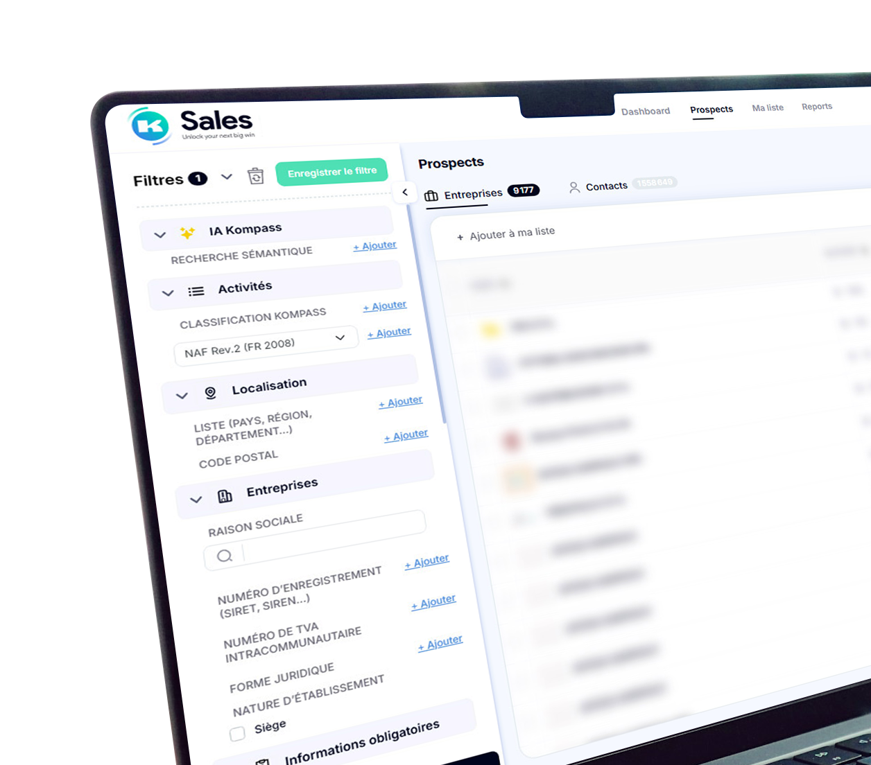
All-in-one prospecting solution designed to improve your productivity
×
Find your next customer today! Your shortcut to faster, more targeted and successful lead generation
Register for free and turn reliable data into real business opportunities
Your data is used to recontact you or send you communications and may be processed by Kompass, for the purposes of legitimate interest (Article 6 1.f of the GDPR). You may object to its processing by email: dpo@kompass.com.